Paddy Dillon
Список книг автора Paddy DillonWalking and Trekking in Iceland
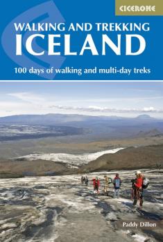
This walking and trekking guidebook offers a total of 49 day walks and 10 multi-stage treks set right across the magnificent country of Iceland. With three national parks including the mighty Vatnajökull, it is a country of incredible beauty, and its capital, Reykjavík, is an established and easy-to-get-to destination. Including popular, such as the classic Laugavegur Trail from Landmannalaugar to Þórsmörk, as well as lesser-known trails, the guide is split into 12 sections that cover all the best walking and trekking to be had in and around Iceland's amazing and awe-inspiring volcanic, glacial landscapes. The routes range in difficulty from easy walks to challenging treks and give readers all the information they need to experience this wonderfully unique destination on foot. Venturing inland to the remote interior and captivating ice caps, and across glaciers, past lakes and around coastlines and geothermal areas, Paddy Dillon's guide to this 'Land of Ice and Fire' encourages visitors to explore all that Iceland has to offer, and will inspire lovers of the great outdoors to return time and time again. The guide gives lots of tips for travellers on a budget as well as details on public transport and accommodation.
The Teesdale Way
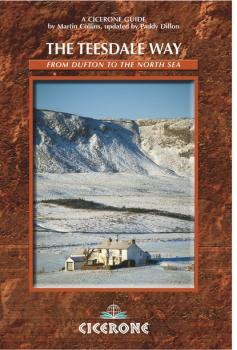
A guidebook to The Teesdale Way which follows the River Tees for exactly 100 miles from its source near Dufton to its outlet at Middlesbrough on the north-east coast. The Way is divided into eight stages of moderate walking and takes up to a fortnight to complete. The route leads through varied country wild moorland and deep dales, many with dramatic waterfalls, gentle pastures and industrial towns.
This guide also includes a selection of 10 circular day walks based on and around the route, with footpaths through fine countryside flanking the river on both sides.
The Wales Coast Path
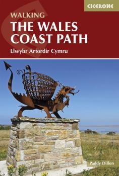
The Welsh Coast Path, at 870 miles is the longest trail in Britain, tracing the coastline from Chester to Chepstow. This guidebook divides the entire coastal path into 9 geographical areas and 57 stages, ranging between 10 to 20 miles in length. However there is no need to stick rigidly to this schedule, as there are usually places where each stage can be broken early, or extended further.
Alongside detailed route descriptions and maps for each stage, the guidebook provides a range of practical information, whether you plan to walk the Wales Coast Path in full, in shorter sections, or as a series day-walks. Travel information, advice on accommodation and planning, as well as details on the history, wildlife and geology of the coast ensure that this is an ideal companion to uncovering the Welsh coast on foot.
Walking on La Gomera and El Hierro
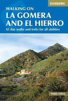
Walking guide to the islands of La Gomera and El Hierro. The 45 waymarked routes in this guidebook include easy strolls and hands-on scrambles, day walks and long-distance routes including the GR132 and parts of the GR131, which runs the whole length of the Canary Islands.
Walks are spread in the guide roughly clockwise and where walks are located beside each other, links between them are often possible, giving you the opportunity to make your own alterations. The routes are described over both islands, with 27 walks on La Gomera and 18 on El Hierro, illustrated with clear contour mapping and inspirational photography.
The two smallest of the Canary Islands are no less rugged than their volcanic neighbours, offering a wide variety of little-known walking terrain from steep-sided barrancos and dramatic cliffs to the gentler slopes inland cloaked in laurisilva and pine forests.
The North York Moors
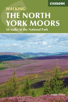
Guidebook to 50 walks in the North York Moors National Park. The walks, which range from 4 to 13 miles, are distributed through seven regions within the park, enabling walkers to discover and appreciate the Tabular Hills, Hambleton Hills, Cleveland Hills, Northern Moors, High Moors, Eastern Moors and Cleveland Coast. For those who like a challenge, the course of the classic Lyke Wake Walk, crossing the national park from east to west, is also described.
For each walk (most of which are circular), step-by-step route description is accompanied by extracts of OS mapping. Points of interest are highlighted, and background information provided, detailing the history and industry of the area. The guidebook also includes planning and preparation details such as when to go, where to stay, and how to get around using public transport.
Comprising the largest continuous expanse of heather moorland in England, the North York Moors offer a wonderful sense of spaciousness, with extensive views under a 'big sky'. People have crossed the North York Moors since time immemorial and some of their routes survive to this day. It is a place of great history and undeniable charm, making it a worthy walking destination.

Mountain Walking in Mallorca
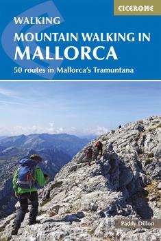
This guidebook presents 50 half-day and day walks in Mallorca's Serra de Tramuntana, the striking limestone range that stretches along the northwestern flank of the island. Whilst the region promises breathtaking scenery and some fantastic walks, there is also some potentially challenging terrain, making guidance when choosing, planning and walking the routes all the more valuable. As many involve steep ground, navigational challenge and hands-on scrambling, these routes are primarily geared towards those with some experience of mountain walking.
Comprehensive route description is illustrated with 1:25,000 Alpina mapping and each walk includes a statistics box to aid route selection. Useful contacts are listed in the appendix. There is also background information on history, plants and wildlife, plus language notes in native Catalan and Castilian Spanish. The routes are spread across the Serra de Tramuntana, with characterful towns and villages such as Sóller, Deià, Fornalutx, Valldemossa and Pollença serving as potential bases for a walking holiday.
Ranging from 5.5km to 24km, the carefully selected routes showcase the region's rugged limestone peaks, mountain and coastal vistas and rich mountain heritage manifested in numerous drystone constructions, charcoal-burning sites and irrigation systems. Highlights include the lush island of sa Dragonera and the dramatic gorge of Torrent de Pareis. The majority of walks are accessible by public transport and many can be linked, opening up further possibilities for exploration.
Trekking in Mallorca
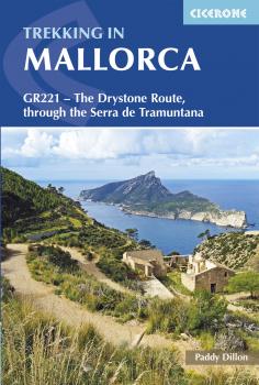
This guidebook describes the GR221, a 140km (87 mile) long-distance trail through northwestern Mallorca, from Port d'Andratx to Pollença. Also known as the 'Ruta de Pedra en Sec' ('the Drystone Route'), the GR221 is a celebration of Mallorca's limestone heritage, taking in many historic drystone structures as it traverses the rocky peaks of the Serra de Tramuntana. Following old stone-paved paths and mule trails, it showcases the region's beautiful landscape of mountains, forests and cultivated terraces, as well as its spectacular coastline.
The GR221 can be walked in 1-2 weeks, although the guide also covers 3 alternative start-points and 3 alternative finishes, which would allow for a shorter trek. The main route is presented in 10 stages of 8.5-20.5km (5-13 miles), with a handful of optional detours to bag neighbouring summits. Detailed route description is accompanied by 1:25,000 mapping and inspirational photography, plus a wealth of information on local points of interest. Accommodation and travel are also thoroughly covered: the trail boasts good transport links and plentiful facilities on route, with accommodation in welcoming mountain villages and the occasional 'refugi'. A comprehensive introduction offers the opportunity to discover more about the region's diverse plants and wildlife and unique history and culture, and an English-Spanish-Catalan glossary can be found in the appendix.
With a favourable climate and stunning scenery, the Serra de Tramuntana has much to tempt the walker. The GR221 Drystone Route represents an ideal way to explore this fascinating World Heritage Site.
The Pennine Way
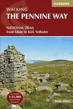
The Pennine Way is Britain's oldest, toughest long-distance footpath – and arguably its most iconic. Now a National Trail, the 427km (265½ mile) route from Edale in Derbyshire to Kirk Yetholm in the Scottish Borders offers wayfarers the opportunity to immerse themselves in wild beauty of the North. The Pennines boast rolling hills, sweeping moorland and wide glacial valleys, and the Pennine Way has come to embody personal challenge and adventure.
This guidebook presents the route in 20 daily stages of 10.5-31.5km (6½-19½ miles). Step-by-step route description is accompanied by 1:100,000 mapping and information about points of interest along the way, as well as advice on facilities and planning your trip, tips for walking the route and an alternative 15-day itinerary. Useful contacts and full accommodation listings can be found in the appendices. In addition, the guide includes a pocket-sized map booklet containing all the OS 1:25,000 mapping needed to complete the trail, saving the need to carry numerous map sheets.
The Pennine Way crosses three National Parks – the Peak District, Yorkshire Dales and Northumberland National Park – and other highlights include Cross Fell, the highest point in England outside of the Lake District; the Cheviot Hills; Kinder Scout; the limestone cliffs of Malham Cove; the North Pennines Area of Outstanding Natural Beauty and the awe-inspiring UNESCO World Heritage Site of Hadrian's Wall. Overnight options range from camping to a mixture of hostels and B&Bs and there is great camaraderie amongst wayfarers. With a wealth of information to help you get the most from your trip, Paddy Dillon's guide is an ideal companion to discovering this classic trail.
Walking in the North Pennines
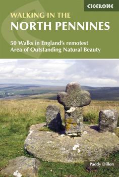
A guidebook to day walks in the North Pennines Area of Outstanding Natural Beauty (AONB), across Cumbria, County Durham and Northumberland. The book includes 50 walks exploring England's 'last wilderness', ranging from 5 miles (8km) to 14 miles (23km). The walks, which work well from bases such as Hexham, Barnard Castle, Alston, Kirkby Stephen and Appleby are mostly circular, with a smaller selection of linear routes, and there is something to suit all abilities over a variety of terrain.
Route descriptions are illustrated with OS 1:50,000 mapping and colour photographs, and the book includes details of local transport services, accommodation and tourist information centres. The walks cover a variety of terrain, from flat railway trackbeds to pathless moorland, and provide the opportunity to explore the striking geological features and fascinating industrial heritage of the area.